Northern Ireland is the great paradox of UK gold. Geologically it is in the top rank — the Sperrin Mountains of County Tyrone host Curraghinalt, one of the highest-grade undeveloped gold deposits anywhere in the world, and the Cavanacaw deposit nearby has supported a working mine. The rocks are part of the same Dalradian belt that produces the famous Scottish Highland gold at Tyndrum and Cononish. And yet Northern Ireland has the smallest recreational panning scene of the four UK nations, with no permit sites and most of the best ground locked under commercial licence. This guide is the honest version of "where".
The article works through the geology, sets out the world-class hard-rock deposits and what they mean for a hobbyist, names the rivers a recreational prospector can realistically work, and covers the distinct Northern Ireland legal framework — which is genuinely different from the rest of the UK. Every relevant river is on the UK Gold Prospector interactive map with current access notes. The companion regional guides on Scotland, England and Wales complete the UK set.
In this guide
- The Northern Ireland gold paradox
- The geology — the Dalradian Sperrins
- Curraghinalt — a world-class deposit
- Cavanacaw and the Omagh Mine
- The Sperrin rivers a hobbyist can work
- The Bronze Age gold tradition
- Northern Ireland gold-panning law
- Best season and realistic expectations
- Frequently asked questions
See the UK gold map for yourself
All 211+ BGS-verified UK locations with GPS coords, access notes and geology — the Sperrins, the Tyrone gold belt and every mainland region, mapped in seconds.
The Northern Ireland Gold Paradox
To understand gold in Northern Ireland you have to hold two facts in your head at once. The first is that the region's hard-rock gold is genuinely world-class. The Curraghinalt deposit in the Sperrin Mountains has been assessed as one of the highest-grade undeveloped gold deposits on the planet, and the County Tyrone gold belt that hosts it is a serious gold province by any international standard. The second is that the recreational gold-panning hobby in Northern Ireland barely exists. There is no equivalent of the three Scottish permit sites, no event in the cultural memory comparable to the 1868 Sutherland rush, and no established network of hobbyists working known rivers the way Scotland and Wales have developed.
Three things explain the gap between the geology and the hobby. The first is that the best gold is hard-rock vein gold sitting deep in licensed commercial ground, not free-flowing alluvial gold in accessible rivers — the kind of gold a mining company recovers, not the kind a hobbyist pans. The second is the legal framework, which is different from Great Britain in ways that genuinely matter and which keeps most of the prospective ground under exclusive commercial mineral licence. The third is simply history: Northern Ireland never had the headline gold rush that would have built a recreational culture, and the island's one true rush — the 1795 Wicklow rush at the Goldmines River — happened far to the south, in what is now the Republic of Ireland.
What this means for a recreational prospector is straightforward. The alluvial gold eroded from the Sperrin and Tyrone deposits is real and it is in the rivers, and a careful hobbyist working a permitted Sperrin-draining stretch can recover small flakes. But the activity is exploratory rather than established, the legal preparation is more involved than booking a Scottish permit, and the realistic returns are modest. For the historical chronology of every major UK strike, see our UK Gold Rushes hub.
The Geology — the Dalradian Sperrins
Northern Ireland's gold comes overwhelmingly from one geological province: the Dalradian Supergroup rocks of the Sperrin Mountains, straddling County Tyrone and County Londonderry. This is the same broad sequence of metamorphosed sedimentary and volcanic rocks — formed and deformed during the Caledonian mountain-building event hundreds of millions of years ago — that hosts the major Scottish Highland gold belt around Tyndrum and the Cononish mine. Before the Atlantic opened, the Dalradian rocks of the Sperrins and the Dalradian rocks of the Scottish Highlands were part of a single continuous belt, and the gold mineralisation they share reflects that common origin.
The gold itself sits in quartz veins that formed when hot, mineral-rich fluids moved through fractures in the Dalradian host rock during and after the Caledonian deformation. These hydrothermal veins carry gold along with sulphide minerals, and where they are rich and continuous they form the kind of primary deposit a mining company can work. Curraghinalt is the outstanding example. Over the long span of geological time since, weathering and the Pleistocene glaciation have eroded the surface, liberated gold from the exposed and near-surface veins, and concentrated the eroded fragments into the gravels of the rivers that drain the range.

There is a second, smaller geological contribution to note: the Tyrone Igneous Complex, an older sequence of volcanic and intrusive rocks to the south and west of the main Dalradian outcrop, which carries its own mineralisation and overlaps the gold-prospective ground around Omagh. For a recreational prospector the practical point is the same across both: what you can recover with a pan is alluvial flake gold from re-sorted river gravels, never the primary vein material, and the most prospective rivers are those that drain the gold-bearing Dalradian and Tyrone Complex country. Full technique is in our river-reading guide.
Curraghinalt — a World-Class Deposit
Curraghinalt, near the village of Greencastle in the Sperrin Mountains of County Tyrone, is the deposit that puts Northern Ireland on the international gold map. It is a structurally controlled quartz-vein system hosted in Dalradian rocks, and successive exploration campaigns have established it as one of the highest-grade undeveloped gold deposits in the world — the defining word being grade, the concentration of gold per tonne of rock, which at Curraghinalt is exceptional by global standards. The deposit has been the subject of extensive drilling, resource estimation and proposals for an underground mine, and it has been a focus of significant investment and considerable local debate over the years.
For a recreational prospector, Curraghinalt is essential context rather than a destination. It is licensed commercial ground, not an open or permit-backed recreational site, and it cannot be visited or worked by hobbyists. What it tells you is why the surrounding Sperrin rivers carry the alluvial gold they do: a deposit of this richness, eroding over geological time, seeds the local drainage with the flake gold that a careful panner can later recover downstream. The deposit's existence is the single strongest piece of evidence that the County Tyrone gold belt is the real thing.
A point worth stating plainly: the presence of a world-class deposit nearby does not make the adjacent rivers easy or legal to work. Much of the most prospective ground in the Sperrins sits under exclusive commercial mineral licence administered by the Department for the Economy, and a recreational prospector still needs landowner permission and environmental compliance for any specific stretch. World-class geology and accessible recreational opportunity are not the same thing.
Cavanacaw and the Omagh Mine
The second pillar of the County Tyrone gold story is Cavanacaw, west of Omagh, where the Omagh Mine has worked the Cavanacaw gold deposit — the most developed gold-mining operation in Northern Ireland. Like Curraghinalt, Cavanacaw is a Dalradian-hosted quartz-vein system, and the operation has been the basis for marketing gold of genuine Northern Irish origin, including its use in jewellery sold on the strength of its local provenance.
The wider Omagh area sits at the meeting point of the Dalradian rocks and the Tyrone Igneous Complex, which is part of why the district is so prospective. As with Curraghinalt, the mine and its licence area are commercial ground and not accessible to recreational prospectors. The relevance to a hobbyist is, again, the alluvial halo: the rivers and streams draining the Cavanacaw and wider Omagh gold country carry the eroded signature of that mineralisation, and it is in those drainages — on permitted, non-licensed stretches — that recreational flake recovery is realistic.
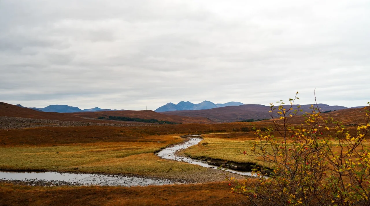
The Sperrin Rivers a Hobbyist Can Work
The recreational opportunity in Northern Ireland is the network of rivers and streams draining the Sperrin Mountains. These are the watercourses that carry the alluvial gold eroded from the Dalradian gold belt, and they are the only realistic ground for a pan-only prospector. None of them is a permit-backed site; every one of them requires landowner permission and environmental compliance, and some stretches fall within commercial mineral licence areas that a recreational prospector must avoid.
The Glenelly and the Owenkillew
The Glenelly River, running east through the heart of the high Sperrins from the watershed near Sawel — the range's highest peak — down through Glenelly Valley, drains some of the most gold-prospective Dalradian country in Northern Ireland. The Owenkillew, to the south, drains a parallel swathe of the same belt and joins the Strule near Newtownstewart. Both rivers and their feeder burns carry the geological signature of the surrounding gold country, and both run through a mix of upland farmland and conservation-designated ground where landowner permission is the practical first step before any session.
These are classic upland gold rivers in form: steep headwater burns feeding into wider valley-floor reaches, with the gold concentrating in the same trap families a prospector would read on any Scottish Dalradian burn — bedrock cracks where the schist is exposed, pressure shadows behind boulders, and the tails of gravel bars on the gentler stretches. The flake gold, where recovered, is fine, and careful classification matters.

The Moyola and the Londonderry side
On the County Londonderry side of the range, the Moyola River drains the northern and eastern Sperrins down toward Lough Neagh, and it has long been associated with gold occurrence in the regional geological literature. The Moyola and the smaller streams draining the north face of the Sperrins carry the same Dalradian gold signature as the Tyrone rivers to the south. As elsewhere in Northern Ireland, the legal and access position has to be worked out stretch by stretch.
The Owenreagh and the smaller burns
The Owenreagh and the dense network of smaller burns draining the high Sperrins complete the recreational picture. These headwater streams are short, steep and boulder-strewn, and they read clearly at low summer water to a prospector with experience on Highland burns. They are also, almost without exception, in country where conservation designations and grazing tenure overlap, so the groundwork of identifying and securing permission is unavoidable. The reward for that groundwork is the chance to work genuinely gold-bearing Dalradian rivers that almost no one else is panning.
Reading the Sperrin burns
The technique on the Sperrin rivers is essentially identical to Tyndrum or Wanlockhead, which makes sense given the shared Dalradian geology. The trap families are the same — bedrock cracks, boulder pressure shadows, gravel-bar tails, and the false bedrock that glacial till provides. The one practical caveat is the same one that applies across the finer-gold UK regions: Sperrin flake gold is fine on average, so careful classification and patient final-stage panning matter. A quarter-inch classifier is the workhorse, with a finer sieve worth carrying for the final concentrate work. Full technique is in our river-reading guide, and the kit list is in our UK equipment guide.
The Bronze Age Gold Tradition
Northern Ireland's modern gold story sits on top of a far older one. Ireland as a whole was one of the most prolific gold-working centres of Bronze Age Europe, and Irish gold ornaments — lunulae, torcs, collars and dress fasteners — survive in remarkable quantity and quality. The Broighter Hoard, found in County Londonderry, is among the most celebrated single discoveries of Irish goldwork, and the broader tradition demonstrates that workable gold has been part of these landscapes for thousands of years.
The source of Ireland's prehistoric gold is still debated by archaeologists. Some research has pointed to alluvial gold from rivers, including the kind of Dalradian-sourced drainage found in the Sperrins; other studies have argued for sources further afield or for complex patterns of trade and recycling. For a modern prospector the debate is less important than the underlying truth it confirms: the rivers of the north of Ireland have been yielding gold, in one form or another, since long before any written record. The deep history is part of what makes panning a Sperrin burn feel like working ground with genuine continuity.
Northern Ireland Gold-Panning Law
This is the section that matters most, because Northern Ireland's legal framework for gold is genuinely different from Great Britain's. Anyone who has read the Scotland, England or Wales guides should not assume the rules carry across — they do not. There are four overlapping layers, and the first one is the one that catches people out.
Layer 1 — the Department owns the gold, not the Crown Estate
In England, Wales and Scotland, unworked gold and silver belong to the Crown and are administered by the Crown Estate (or Crown Estate Scotland). Northern Ireland is different. Under the Mineral Development Act (Northern Ireland) 1969, rights to most minerals — gold among them — are vested in the Department for the Economy, which administers prospecting and mining licensing through its minerals and petroleum function. There is no recreational gold-panning licence scheme of any kind. The practical consequence is that the body that controls Northern Ireland's gold is a devolved government department, not the Crown Estate, and that much of the prospective Sperrin ground is held under exclusive commercial mineral licences granted by that department. Anyone contemplating anything beyond casual hand-pan recreation should confirm the current position directly with the Department for the Economy before proceeding.
Layer 2 — landowner permission
Northern Ireland does not have a statutory right of responsible access equivalent to the Land Reform (Scotland) Act 2003. Access to rural land and riverbanks operates on the basis of landowner permission, and for gold panning the working assumption is that direct permission from the landowner for the specific stretch of riverbank is required for every session — written down where possible, with the scope of the permitted activity clearly described. River fishing rights and bankside ownership in Northern Ireland can be complex, so identifying the correct holder is part of the groundwork.
Layer 3 — DAERA, the NIEA and protected sites
The environmental framework is administered by the Department of Agriculture, Environment and Rural Affairs (DAERA) and the Northern Ireland Environment Agency (NIEA), with the Loughs Agency also relevant for cross-border catchments. The good-practice expectations parallel those in Great Britain: hand-tools only, refilling any disturbance the same day, and observing the spawning closure that protects salmon and trout in the relevant catchment. Much of the Sperrins is designated — the Sperrin Area of Outstanding Natural Beauty covers a large part of the range, and numerous stretches are notified as Areas of Special Scientific Interest (ASSIs), the Northern Ireland equivalent of the SSSI, with separate consent requirements administered by the NIEA. The default position at any productive Sperrin site is to assume designation until a site-specific check confirms otherwise.
Layer 4 — the Treasure Act 1996
The Treasure Act 1996 applies in Northern Ireland as it does in England and Wales. Alluvial flake gold recovered from a stream by a hobbyist using a pan does not in itself meet the technical definition of "treasure" — the Act applies principally to coin hoards, prehistoric metalwork in association, and certain qualifying finds — but any prospector who recovers a worked object of historical interest from river gravel needs to consider the Act's reporting requirements. In Northern Ireland, archaeological finds are reported to the Ulster Museum / National Museums NI, and given the region's extraordinary Bronze Age gold tradition, the possibility of an archaeologically significant find is not merely theoretical. The default position for any non-natural find is to record it, leave it in place where possible, and report it. Full detail is in our UK gold panning laws guide.
Best Season and Realistic Expectations
The hydrological and ecological seasons for Northern Ireland follow the same broad pattern as the rest of the UK, adjusted for the region's mild, wet Atlantic climate.
The hydrological window
Low summer water is the productive condition, typically from mid-June through mid-September in an average year, when the rivers drop and the gravel features become readable and reachable. The single most productive sampling opportunity is the window after a major winter or autumn spate — two to six weeks after the storm, once the water has cleared and dropped to working level — because the river has re-sorted its gravels and laid down fresh pay-streaks. Northern Ireland's wet climate means spates are frequent and the rivers can colour up quickly, so flexibility about timing matters more here than in drier parts of the UK.
The ecological window
The Sperrin rivers support important salmon and trout populations, and the spawning closure protecting them is the key seasonal constraint. The Glenelly, Owenkillew, Moyola and the wider Foyle and Bann systems are managed for migratory fish, with the Loughs Agency and DAERA the relevant authorities. Any session needs to be planned with explicit reference to the closure calendar for the specific catchment, and avoided entirely during the protected spawning period — disturbing redds is both ecologically damaging and an offence.
Realistic expectations
An honest summary of what a recreational prospector can expect in Northern Ireland: fine flake gold and the occasional small picker from the productive features on the Sperrin-draining rivers, recovered after careful work on a permitted, non-licensed stretch. The geology is world-class, but the world-class gold is in the licensed hard-rock deposits, not free in the rivers — what reaches a hobbyist's pan is the fine alluvial fraction. The realistic outcome for a half-day session, working hand tools competently on a good feature, is a snuffer bottle of black sand with visible colour and a few flakes worth bottling. The full kit context is in our UK equipment guide, and the beginner's route in is in the beginner's guide.
The pragmatic reading for any Northern Ireland-based prospector: treat the Sperrin rivers as genuinely special exploratory ground — Dalradian gold country that almost no one else is panning — but do the legal groundwork first, every time. Build technique locally under landowner permission, and consider one trip a year to a permit-backed Scottish site for a guaranteed productive weekend. Northern Ireland is where you work the road less travelled; Scotland is where you bank the certainty.
Frequently Asked Questions
Is there really gold in Northern Ireland?
Yes — and geologically Northern Ireland holds some of the richest gold in the British Isles. The Curraghinalt deposit in the Sperrin Mountains of County Tyrone is one of the highest-grade undeveloped gold deposits in the world, and the Cavanacaw deposit near Omagh has been worked at the Omagh Mine. The paradox is that this world-class hard-rock gold sits in a region with almost no recreational panning tradition. The gold a hobbyist can recover with a pan is alluvial flake from the rivers draining the Sperrin and Tyrone gold belt, and it is genuinely there, but the recreational scene is the smallest of the four UK nations.
Where is the best place to pan for gold in Northern Ireland?
The rivers draining the Sperrin Mountains of County Tyrone and County Londonderry are the realistic recreational ground — the Glenelly, the Owenkillew, the Owenreagh, the Moyola and their tributaries all drain the Dalradian rocks that host the region's primary gold. There is no permit-backed recreational scheme equivalent to the Scottish sites at Wanlockhead, Kildonan or Tyndrum, so every Northern Ireland session needs landowner permission and environmental compliance organised separately. Much of the most prospective ground also sits under active commercial mineral licences, which adds a layer not present in Great Britain.
Do I need a permit to pan for gold in Northern Ireland?
Northern Ireland's mineral law is different from the rest of the UK. Under the Mineral Development Act (Northern Ireland) 1969, rights to most minerals — including gold — are vested in the Department for the Economy rather than the Crown Estate, and the Department administers prospecting and mining licences. There is no recreational gold-panning licence scheme. The practical legal route for a hobbyist is direct landowner permission for the specific stretch of riverbank, plus compliance with DAERA and Northern Ireland Environment Agency conditions and any ASSI or AONB restrictions. Anyone contemplating anything beyond casual hand-pan recreation should confirm the position directly with the Department for the Economy. Full legal detail is in our UK gold panning laws guide.
What is the Curraghinalt gold deposit?
Curraghinalt, near Greencastle in the Sperrin Mountains of County Tyrone, is one of the highest-grade undeveloped gold deposits in the world — a quartz-vein system hosted in Dalradian rocks, the same broad geological province that hosts the Scottish Highland gold at Tyndrum and Cononish. It has been the subject of extensive exploration and a proposed underground mine. For a recreational prospector it is important context rather than a destination: it is licensed commercial ground, not an open site, and confirms why the surrounding Sperrin rivers carry the alluvial gold they do.
Is there an operating gold mine in Northern Ireland?
The Omagh Mine at Cavanacaw, west of Omagh in County Tyrone, has worked the Cavanacaw gold deposit and is the most developed gold mining operation in Northern Ireland. The gold from the region has been used to market Irish-sourced gold jewellery. As with Curraghinalt, the mine sits on commercial mineral licences and is not accessible to recreational prospectors, but its existence underlines that the County Tyrone gold belt is a genuine, economically significant gold province.
How does Northern Irish gold compare to Scottish or Welsh gold?
Geologically, Northern Ireland is in the top rank — the Dalradian-hosted Curraghinalt deposit is comparable in grade and significance to the best Scottish hard-rock gold. Recreationally, it is the opposite: Northern Ireland has the smallest hobby panning scene of the four UK nations, with no permit sites, no equivalent of the 1868 Sutherland rush, and most of the best ground locked under commercial licence. The honest summary is that the rock is world-class but the accessible recreational opportunity is modest. The full UK comparison is in our UK Gold Rushes hub.
What was the Bronze Age gold connection in Ireland?
Ireland was one of the most prolific gold-working centres of Bronze Age Europe, and Irish gold ornaments survive in remarkable quantity. Finds such as the Broighter Hoard from County Londonderry show the sophistication of the tradition. The source of much of this prehistoric gold is still debated by archaeologists — some of it may be alluvial gold from rivers like those of the Sperrins, some from sources further afield — but the deep history confirms that workable gold has been moving through these landscapes for thousands of years.
Was the Wicklow gold rush in Northern Ireland?
No. The famous 1795 gold rush at the Goldmines River below Croghan Kinshela in County Wicklow — the largest gold rush in the history of the British Isles by the quantity of alluvial gold recovered in a short period — is in the Republic of Ireland, not Northern Ireland, and falls outside both the UK legal framework and the scope of this guide. It is worth knowing about as the island's headline gold story, but a UK-based prospector planning a trip should focus on the Sperrin rivers of County Tyrone and Londonderry.
Where should a Northern Ireland beginner start?
Start with the law and the landowner, not the river. Identify a Sperrin-draining stretch — somewhere on the Glenelly, Owenkillew or Moyola catchments — where you can secure landowner permission, confirm the stretch is not under a restrictive ASSI notification or an exclusive commercial mineral licence, and check the DAERA spawning-closure calendar. Treat the first season as practice. For a first productive weekend, many Northern Ireland prospectors still travel to one of the permit-backed Scottish sites, with Wanlockhead in the Southern Uplands the most accessible by ferry. The full route in is in our beginner's guide.
Important: Gold panning in Northern Ireland is governed by a different legal framework from Great Britain. Under the Mineral Development Act (Northern Ireland) 1969, rights to gold are vested in the Department for the Economy, which administers mineral licensing — there is no recreational gold-panning licence scheme, and much prospective ground is under exclusive commercial licence. Always obtain landowner permission and check ASSI, AONB, DAERA, NIEA and Loughs Agency conditions and the spawning closure before working any river. Never dig the bank. The Treasure Act 1996 applies — report any worked or archaeological find. This article is general guidance, not legal advice — verify current law with the Department for the Economy, DAERA or the relevant authority for your area. Full detail in our UK gold panning laws guide.
211+ BGS-verified UK gold locations including the Sperrin and Tyrone gold belt — access notes, geology and the wider regional picture.
Open the Interactive Map →Free Beginner's Pack — 16-page PDF: top 10 UK locations with GPS, equipment checklist, legal cheat sheet and app tutorial.
Get the Free Pack →