As an Amazon Associate, UK Gold Prospector earns from qualifying purchases.
Reading a river for gold is the single skill that separates a productive day from a wet, cold, empty one. Most beginners pan the wrong gravel for the right reasons — the spot looked nice, the water was easy, the bank was flat. Gold doesn't care about any of that. It cares about velocity, density, and obstructions. Once you understand how a river sorts its load, every stretch of water you walk reads like a map of where to dig.
This is the long version. It covers the physics, the six major gold traps, the geometry of less obvious ones, true and false bedrock, how the river changes between flood and low water, what the named UK gold rivers actually look like at ground level, the method for sampling a new stretch, the mistakes that quietly cost people gold, and the realistic UK expectation for what you'll find when you do it right. It is written for hobbyists working a pan and a trowel — not for commercial dredging operations — and everything in it applies on the UK rivers covered by our interactive map.
In this guide
- Why gold settles where it does
- The six major gold traps in UK rivers
- The geometry of deposition — bends, boulders, confluences and plunge pools
- True bedrock, false bedrock, and why it matters
- High water and low water — how flow changes the map
- UK rivers read in detail
- Walking a new stretch — a step-by-step method
- Mistakes that quietly cost you gold
- Kit, law, and an honest reality check
- Frequently asked questions
See real gold-bearing UK rivers on the map
All 211+ BGS-verified UK gold rivers with GPS coords, geology overlays and access notes — apply what you've read on a real stretch.
Why Gold Settles Where It Does
Gold has a specific gravity of around 19.3. That number is the foundation of everything else. Specific gravity is the ratio of a substance's density to that of water — so gold is 19.3 times heavier than the same volume of water. To put that in context, the quartz, sandstone and mudstone pebbles that make up most UK river gravel sit at around 2.6 to 2.8. Magnetite — the black sand prospectors look for — is 5.2. Garnet is between 3.5 and 4.3. Pure gold is roughly seven times denser than the average pebble it travels next to.

That density gap is why gold concentrates at all. A river is a kinetic filter. Fast water has the energy to carry heavy particles — pebbles, sand, gold flakes — along its bed. Slow water doesn't. The moment flow drops below a particle's transport threshold, that particle stops. Lighter material keeps moving downstream. Heavier material stays. Over the lifetime of a river that mechanism sorts the load: quartz pebbles end up everywhere, gold accumulates in a handful of predictable places.
There is a more precise way to put this. Geologists talk about hydraulic equivalence: the condition where two grains of different density settle out at the same flow velocity. A small grain of gold and a much larger grain of quartz can be hydraulically equivalent. That is why gold-bearing gravel is graded the way it is — coarse pebbles with the small dense gold tucked into the matrix between them. If you pull a fistful of gravel out of a productive pay layer, the gold is not on top of the cobbles, it is jammed between and beneath them, sitting where the velocity at the bed dropped just enough to let it fall.
Three practical consequences follow from this. First, gold is always at the bottom of the gravel column, not the top — so surface skimming is wasted effort. Second, gold moves only at flood-stage velocities — so the river you can wade through in July is showing you the leftovers of February's storms. Third, gold and the heavy black-sand minerals travel together — so where you see no black sand, you can almost certainly assume there's no gold either.
The Six Major Gold Traps in UK Rivers
Every productive spot on a UK river belongs to one of six trap families. Memorise these and you have the working vocabulary for the rest of the article. They are not a hierarchy — the right one for any given day depends on the river, the time of year, and what the last flood did.
1. Inside bends (point bars)
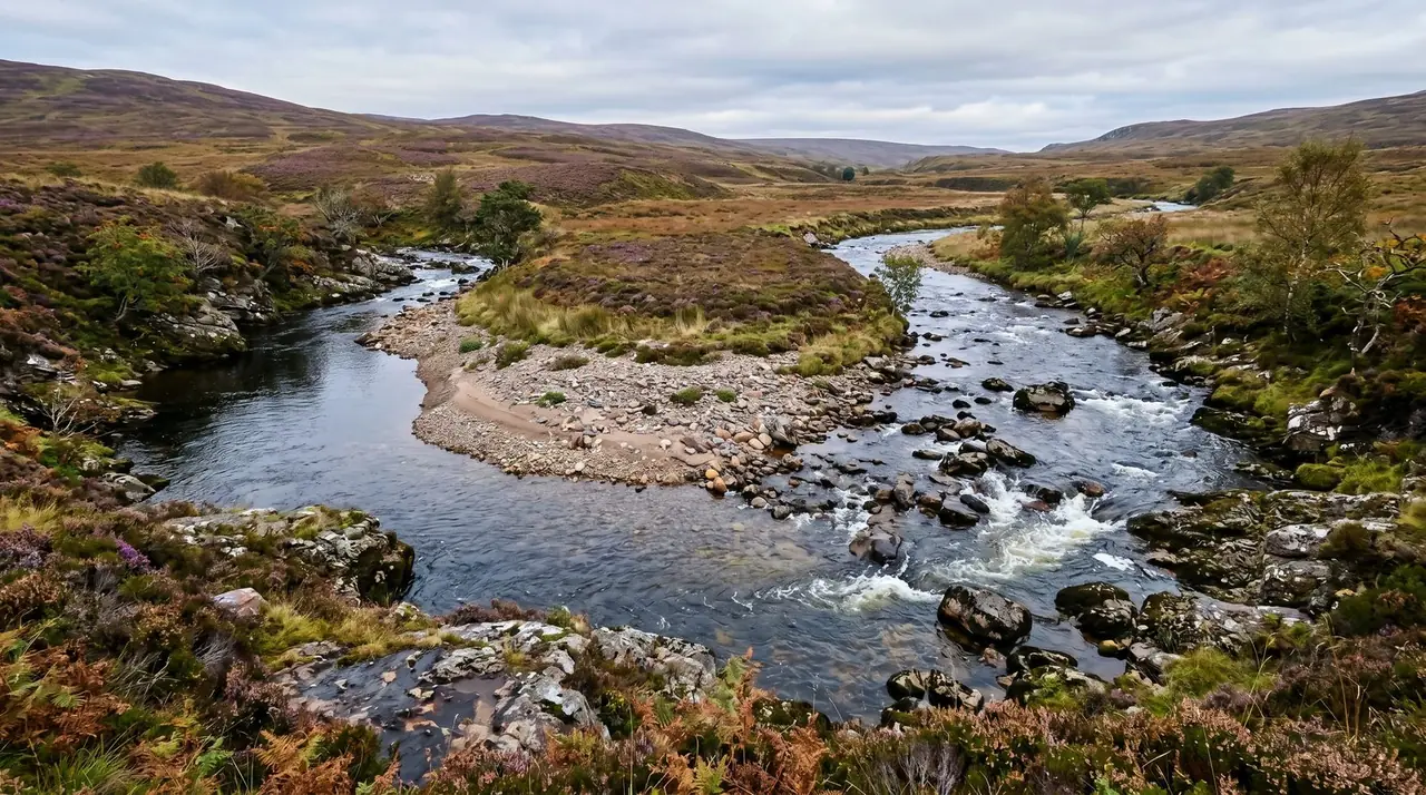
The single most consistent producer in UK rivers. When a river curves, the water on the outside of the bend travels further per second and the current is faster — that is the side that erodes the bank. On the inside of the bend, the current slows, and material drops out of suspension. Over time a gravel bar builds up on the inside, often vegetated above the active waterline.

Two things matter when reading an inside bend. The first is where the deepest, slowest water of the previous flood sat — that's where the pay-streak will be, and it is usually not in the same place as the lazy low-water current you are looking at on a summer afternoon. Look at the visible bar and project the flood-stage shoreline backwards from the debris caught in the bankside scrub. The flood line traces the active deposition zone. The second thing is grass and tree roots. Where vegetation has grown over part of the bar and roots have reached down into the gravel, the roots act as a natural sieve — pulling gold out of any flood water that washes over them. Digging directly under turfed gravel above an inside bend is one of the highest-percentage moves in UK prospecting.
2. Behind boulders (pressure shadows)
Every obstruction in a river creates a pressure shadow — a zone of slow, swirling water immediately downstream of the obstruction. Boulders, exposed bedrock outcrops, fallen logs, even large submerged cobbles all generate them. The boundary between fast water and the pressure shadow is called the eddy line, and gold settles inside that shadow as soon as it crosses it.

The size of the boulder matters less than its position. A house-sized rock in slack water traps nothing — there was no gold being moved past it. A waist-high boulder sitting in the middle of fast riffle water can be one of the richest features on the river. The best are mid-stream boulders sat on or close to bedrock, with the shadow falling onto a hard surface or into a downstream crack. Smaller stones in clusters — a boulder field — work the same way at miniature scale: gold settles in the gaps between every stone where the flow eddies. Crevice tools and a stiff brush will get you into the gaps that a trowel cannot reach.
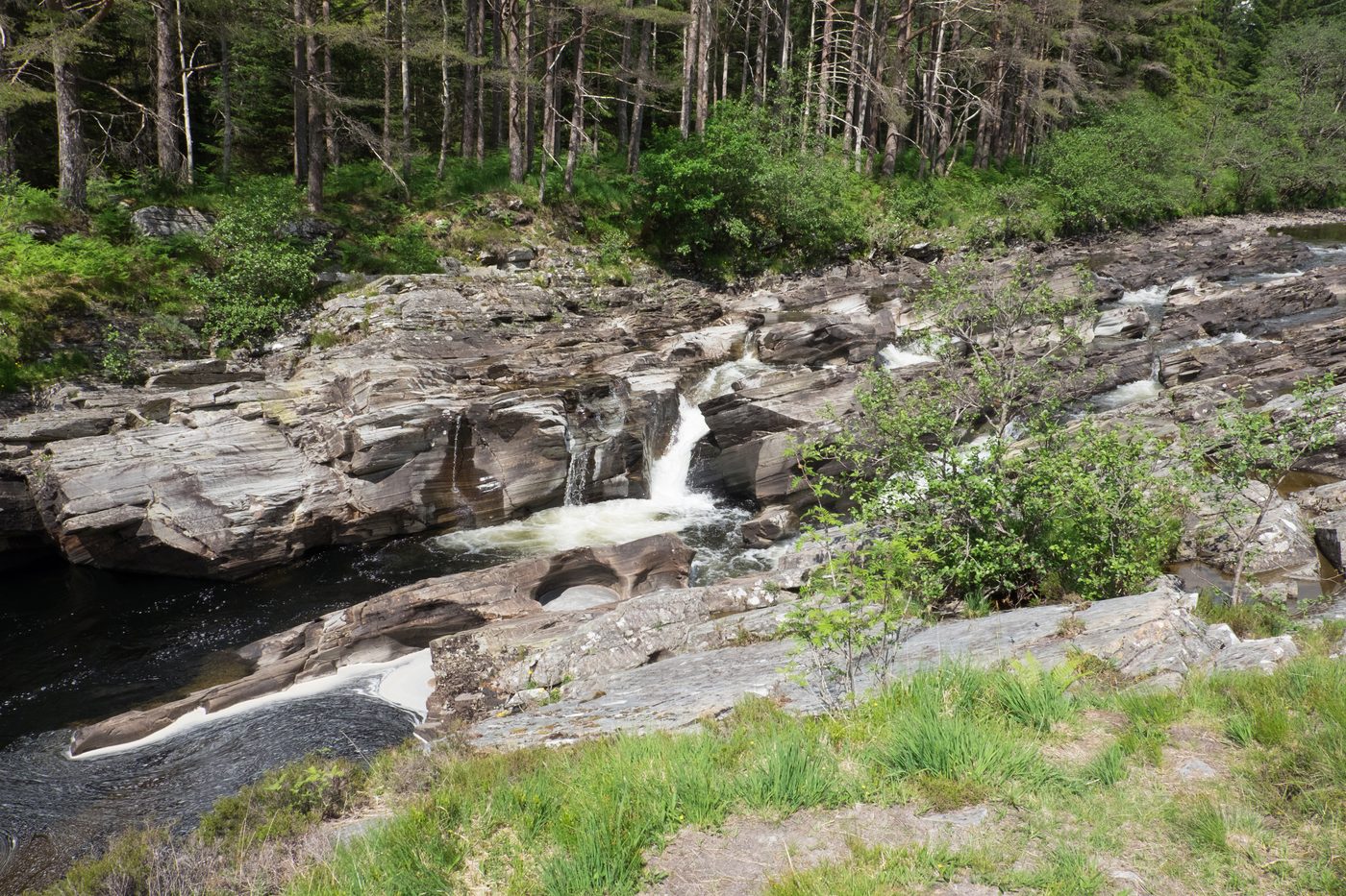
3. Bedrock cracks and crevices
Once a gold particle reaches bedrock it doesn't come back up. Every crack, hole, joint and irregularity in the rock face becomes a permanent trap. Over decades and centuries, gold accumulates in these features faster than anywhere else on the river. Bedrock crevice work is the highest grade-per-shovel prospecting in the UK by a large margin — when you find a productive bedrock exposure, every pan should show colour, and the deepest crevices may give you pickers rather than just flakes.

What to look for: bedrock exposed at low water, particularly where its layers run roughly perpendicular to the flow direction. Layers that dip downstream funnel gold up against the upstream face; layers that dip upstream let gold fall straight in. Quartz veins running through bedrock are often softer than the surrounding rock and erode out into ready-made channels — these are some of the best features anywhere on a UK river. The technique is plastic crevice picks, a stiff-bristled brush, and a snuffer bottle. Work each crack methodically from the surface down to the bottom; do not chip or break the bedrock, both because it changes the natural trap and because in the UK it raises questions under environmental and SSSI law. The rule of thumb among experienced prospectors is that the highest-grade material sits in the deepest, narrowest part of the crack, where almost no current ever reached it.
4. Root mats and moss banking
Where tree roots, fibrous turf, or thick beds of aquatic moss reach down to the gravel surface, they trap fine gold the same way an artificial sluice mat does. The fibres are dense, irregular, and constantly damp; heavy flakes settle into them during high-flow events and stay there. UK rivers running through wooded stretches — large parts of the Mawddach catchment, parts of the upper Tyne and Tees, and woodland sections of the Helmsdale tributaries — have plenty of these features.

To work a root mat, cut a representative sample of the lower fringe — just the section that has been sitting in flowing water during a flood — and wash it thoroughly into a bucket or directly into your pan. The fine flake gold collects in the bottom along with black sand. A dried moss sample can be burned to ash to recover what's bound up in the fibres, though this is something most hobbyists skip and just wash thoroughly. Note that digging into the bank itself to access roots is illegal in the UK — bank otter holts and water vole burrows are protected, and bank digging is a criminal offence regardless of permission. Work only what is reachable from the bed.
5. Gravel bars
A gravel bar is the larger-scale cousin of an inside bend deposit — a broad accumulation of cobbles, pebbles and sand that has built up across a slacker section of the channel. Some are mid-stream (a chevron or longitudinal bar splitting the flow), some are tied to the inside of a bend, some are at the mouth of a tributary. They are the most obvious feature on most UK rivers and the most commonly worked feature for that reason.
The trick with gravel bars is that gold is not evenly distributed across them. There is a head (upstream end), a middle, and a tail (downstream end). The head is usually coarse cobbles — gold settles there during the early part of the flood. The tail is usually finer material — fine gold and flour gold accumulate there as the flood recedes. The middle is mixed. Sample all three before committing to one. Within the bar, gold concentrates where coarse gravel meets finer material, and along any line where the flood water visibly slowed — the inside edge facing the slack water, not the outside facing the current.

6. Riffles and natural sluices
Riffles are stretches of shallow fast water running over a bed of cobbles or boulder steps. Each stone is a tiny obstruction, each pair of stones is a tiny eddy. The result is a natural sluice — the same mechanism a sluice box uses, scaled up across a metre or more of riverbed. Gold settles between and behind the cobbles, often into a visible line that follows the riffle for several metres. Long-time prospectors talk about the "gold line" — the path of highest deposition during flood stage — and it is often most readable in a riffle.
Riffles are particularly productive on the small upland burns of the Scottish Highlands and Southern Uplands, where the entire stream channel is effectively one continuous shallow riffle bouncing over a cobble bed. The technique is straightforward: lift the larger cobbles, scoop the fines and small gravel from underneath into your pan, and work systematically across the channel. Cracks in any exposed bedrock at the base of the riffle are the highest-grade feature anywhere on it.
The Geometry of Deposition — Bends, Boulders, Confluences and Plunge Pools
Beyond the six headline traps, there are several features that work by the same principles but warrant a separate mention because they are commonly misread. The general rule is that anything in the river that causes a sudden drop in velocity will trap heavy material. Anything that causes a sudden increase in velocity will scour it away.
Confluence drops
Where a tributary enters a main river — a burn meeting the Helmsdale, a side-stream meeting the Mawddach — both currents brake at the merge. The combined volume of water then needs a few metres downstream to settle into its new flow regime. That settling stretch, immediately below the confluence, is one of the most reliable trap features on any river. Productive zones are typically on the downstream side of the tributary mouth, in the slack water created by the angle of intersection, and along the line where the two waters' different velocities are still visible at the surface.
One nuance: where a small productive tributary enters a much larger main river, you sometimes get a short "tributary deposit" — a narrow streak of gold extending a short way down the main river from the mouth, before the gold transitions onto the main river's gold line. If you have evidence that a tributary drains gold-bearing rock, sample the first 20–50 metres of main river below its confluence before you sample anywhere else.
Plunge pools and the second-pool rule
The deep pool at the base of a waterfall is an obvious gold trap and a counter-intuitive one. Obvious because heavy material falling over the lip has nowhere to go but down. Counter-intuitive because the immediate plunge pool is often churned by the falling water and recirculates its contents — so the gold may not settle there at all, and certainly not where you'd expect. The richest pool is frequently not the plunge pool itself but the next pool downstream, where the water has slowed enough to drop everything the plunge pool was still suspending.
This pattern is well-documented in older USGS prospecting literature and rediscovered every year by hobbyists who sample the obvious feature and find it disappointing. Always sample both pools. On small UK upland streams with a series of step-pools, the rule generalises: work the bottom of each pool in series, and pay particular attention to the head of each downstream pool where it widens out from the previous step.
Slow-water shelves and pool tails
Pool tails are the transition zone where a deep slow pool runs out into the next riffle. The water shallows and accelerates. That acceleration is the river's last chance to leave heavy material behind, and the pool tail is consequently a high-deposition feature. Sample the back-edge of pool tails — the line where the bed first starts to shallow — before working the riffle below.
High benches and terrace gravels
Some of the richest UK pay-streaks are in gravel that hasn't been part of the active river for centuries or millennia. High benches are old riverbeds left behind as the modern channel cut down into the landscape. They sit several metres above the current river, sometimes much more. In the Helmsdale system, the terrace gravels above the active channels were systematically worked during the 1868–69 gold rush and still produce. In Cornwall, the Carnon valley terraces sit above the historic stream-tin workings. Bench gravel work requires landowner permission everywhere in the UK — you're digging on dry land, not the riverbed — and is a slower, more labour-intensive style of prospecting. But the reward, when you hit an undisturbed terrace pocket, can be exceptional.
True Bedrock, False Bedrock, and Why It Matters
The most expensive mistake in placer prospecting is digging through the gold to get to the bedrock. It happens because bedrock is the obvious target — gold sinks, bedrock is the bottom, therefore dig to bedrock. But "bedrock" in placer terms means anything that stops gold from sinking further, and several things in UK rivers stop gold long before the real basement rock does.

True bedrock
True bedrock is the solid basement rock — the rockhead. On UK gold rivers it is most often Lower Palaeozoic mudstone, sandstone, or slate (Helmsdale, Wanlockhead, Mawddach), occasionally weathered granite (parts of Sutherland and Cornwall), occasionally Carboniferous limestone or sandstone (the Northern Pennines). It is solid, in place, and continuous. Gold sitting on or in true bedrock has nowhere to go: every crack and irregularity holds it, and the deeper a crack is, the better the recovery from its bottom.
False bedrock — three common UK forms
Compacted clay layers. Clays settle out of slow-moving glacial meltwater and from later flood deposits, and over time compact into layers that are hard as cement. Many UK gold rivers — particularly those that drained glacial outwash plains — have clay bands within their gravel sequence. Gold sitting on clay is just as effectively trapped as gold sitting on rock. If your trowel hits a hard yellow-grey or blue-grey surface that doesn't feel like rock, that's a clay false bedrock. Pan what's directly above it before digging through.
Cemented hardpan. A layer of gravel and sand that has been cemented together by mineral precipitates — iron oxides, calcite, silica — until it behaves like a solid pavement. Hardpan typically forms within a few metres of the modern surface and feels like compressed concrete to the trowel. It is an excellent gold trap and a common false-bedrock surface in the UK, particularly in catchments that drain iron-rich rocks.
Glacial till. Boulder clay deposited directly by Pleistocene ice. Till sits over the actual rockhead in much of upland Britain and acts as a basement above the true basement. The Helmsdale catchment, parts of the Cumbrian and Pennine valleys, and the upper Tweed all have substantial till sequences. Gold redeposited on the surface of till during post-glacial flood events stays there. Pan the gravel directly on the till before considering whether to dig through it.
The practical rule
When your trowel stops on something hard, stop and sample before you push through. Two pans from the gravel sitting directly on the hard surface will tell you whether that surface is your pay layer or not. If those pans show colour, you've found your trap — work it, don't go deeper. If the pans are barren, the hard surface is probably real bedrock and digging deeper into its cracks is where the gold actually sits. Either way, you've learned what you needed in five minutes instead of half an hour. The single most useful thing an experienced UK prospector does is test before going further down.
High Water and Low Water — How Flow Changes the Map
Gold moves only at flood-stage velocities. The river you can wade across in August is moving sand and silt at most, and incapable of shifting a flake of gold by even a centimetre. The reorganisation that creates new pay-streaks happens during winter spates and autumn storms — events with discharges five or ten times the summer baseline.
This is why reading the river requires understanding two states of it simultaneously. The state you're looking at — typically low summer flow, when access and visibility are good — is the snapshot. The state you have to imagine is flood stage, because that is what placed the gold in front of you.
Reading flood stage from a low-water river
Several visible features tell you where the flood went and how high it reached:
- Vegetation flattening and bent saplings — show the direction and approximate height of the most recent serious flood. Bent trees pointing downstream mark the active flood channel.
- Debris caught in branches — twigs, plastic, dead leaves trapped a metre or more above the current waterline. The height of trapped debris is the height of the recent peak.
- Scour lines on rocks and boulders — pale strips of cleaned rock at flood-water height, with moss and lichen above and below.
- Active gravel bars vs vegetated bars — active bars (no plants) are getting moved every winter; vegetated bars (grass, moss, small saplings) are above all but the largest flood. The transition zone between them is where annual flood deposition happens.
The flood channel often follows a different path from the low-water channel. A river that meanders gently at summer baseflow may cut across an inside bend in flood, scouring a new pay-streak across what looks at low water like a quiet vegetated bar. The flood channel is where the gold went. The low-water channel is where it's easy to pan. Match the two up.
The post-spate window
The best UK prospecting comes in the falling limb after a major spate. Trying to pan during the flood itself is wasted — water is high, frothy, brown with clay, you can't see the bed, and fine gold can actually ride on surface tension and leave your pan. Wait. Once the river drops back to a recognisable level and the clay has cleared (typically two to six weeks after a serious storm), the river has just re-sorted itself and the pay-streaks are fresh.
UK timing-wise, this typically means working the rivers in late spring and through summer, when the previous winter's storm work has had time to settle and the visible bed is at its most accessible. This aligns happily with the British Gold Panning Association's recommended salmon-protection window (1 October to 31 May avoided), so the legal and practical calendars line up: most legitimate UK prospecting happens June through September. Full detail on the legal framework — including the Brian Wright prosecution and the Crown Estate position — is in our UK gold panning laws guide.
UK Rivers Read in Detail
Different UK rivers reward different reading. The geology, the gradient, and the human history of disturbance all change what to look for. The five regions below produce most of the country's recreational gold and warrant individual treatment. Specific GPS-level locations are reserved for the interactive map and the paid product — what follows is the geomorphological character of each system, which is what you actually need to read it.
The Helmsdale system, Sutherland
The Kildonan Burn and its tributaries — Suisgill, Kinbrace, and others — drain a catchment of Moine metasediments cut by quartz veins and the Strath Halladale granite. The ultimate source of the gold is probably weathered auriferous granite and the associated quartz veins. The systematic variation in gold composition across the catchment — silver-richer in the Suisgill watershed, less so in Kildonan and Kinbrace — points to the upper Suisgill area as the original source.
Reading this system: gradient is moderate, channels are narrow and bouldery, and the dominant traps are bedrock crevices in the schist outcrops, behind-boulder pressure shadows in the riffle stretches, and high-bench terrace gravels above the active channels. The terrace gravels in particular were worked extensively during the 1868–69 Kildonan Gold Rush, when around 2,000 prospectors descended on the area, and substantial terrace material remains. Permit panning is available via the Suisgill Estate on the Kildonan Burn; further sites and the wider regional picture are in our Scotland locations guide.
The Leadhills and Wanlockhead burns, Southern Uplands
The Mennock Water, Wanlock Water, and Glengonnar Water drain the Lowther Hills and the Leadhills–Wanlockhead mining district. The host rock is Silurian Hawick Group sandstone, with stratabound pyrite and arsenopyrite in debris-flow conglomerate beds (up to four metres thick and bearing 0.75 per cent arsenic). The arsenopyrite carries up to 0.4 per cent gold; that's the original source.
The area's history is the Leadhills–Wanlockhead lead-zinc-silver district — over four hundred thousand tonnes of lead, ten thousand of zinc and twenty-five of silver produced between 1700 and 1958. Gold has been panned in the burns since at least 1510 and probably much earlier (likely Roman in origin). Reading these burns: shallow, fast, cobble-floored channels with frequent bedrock exposures, the entire stream effectively one continuous riffle stepping down the hill. Trap types in order of yield are bedrock crevices, pressure shadows behind larger boulders, and gravel-bar tails on the broader stretches. Day licences are available through the Museum of Lead Mining at Wanlockhead.
The Mawddach catchment, Snowdonia
The Afon Mawddach and its tributaries drain the Dolgellau Gold Belt — Middle to Upper Cambrian black mudstones of the Clogau and Maentwrog formations, with composite ribbon-quartz lodes in shear zones above the Bala-Mawddach and Corris-Rhobell fracture zones. This is the source of "Welsh gold" used in royal wedding rings through the twentieth century.
Reading this system at the river level looks classic — wooded valley, varied gradient, plenty of bedrock exposure and boulder fields — and the gold is genuinely there. The legal situation, however, is restrictive. The Afon Mawddach catchment and the Afon Wen are SSSI and SAC, managed by Natural Resources Wales. Gold panning is prohibited on NRW-managed land, and the 2022 prosecution of Brian Wright on the Afon Wen makes that policy a publicly documented criminal conviction with a fine of over £3,000. Supervised commercial gold panning experiences in the Dolgellau area offer the only readily available legal route. Full detail on the law and on legal locations is in our guide to Welsh gold in the Mawddach.
The Cornish streams — Carnon and Hayle drainages
Cornish placer gold travels with cassiterite — tin ore — and the streams of west Cornwall have been worked for both since the Bronze Age. Recent provenance work links Carnon River gold to the Bronze Age Nebra Sky Disk in central Europe, suggesting Cornish placer gold was reaching the continent some 3,600 years ago. The source is the weathering of granite-related mineralisation in the Cornubian Batholith.
Modern realistic expectation: very fine flake gold, often associated with black sand and cassiterite. Reading Cornish streams is reading low-gradient catchments where the gold is typically deep in the gravel column or pinned to old stream-tin worked surfaces below later flood deposits. Bench gravel along the Carnon valley terraces is the highest-grade material historically, and most of it has been worked. Current recreational panning in Cornwall is small-scale and legally complicated — significant parts of the historic stream-tin ground are scheduled monuments or SSSIs, and any disturbance needs careful site-specific checking.
The Northern Pennines and Cumbria
The upper Tyne, Tees and Eden drainages cross the Northern Pennine Orefield — a lead-zinc-fluorspar district where gold is subordinate but present. BGS-era investigations describe the gold as "too scattered and in too small quantities to be worth mining," which for recreational panning is still useful: fine flakes are findable. Specific reported areas include Borrowdale, Sedbergh, the Caldbeck Fells, the upper Eden, and parts of the Tyne and Tees.
Reading these rivers: variable gradient, mixed boulder and cobble beds, occasional bedrock exposures, and a high proportion of post-glacial outwash gravel — meaning false bedrock layers of glacial till are common. The headline traps are bedrock crevices where available, pressure shadows in the upland reaches, and gravel bar tails on the lower runs. Permission requirements apply throughout — England has no statutory access right for prospecting — and the laws guide covers what to check before approaching any specific site.
Walking a New Stretch — a Step-by-Step Method
Reading the river is one half of the skill; the other is having a method for converting that reading into actual flakes in the snuffer bottle. The following is a sampling protocol that works for hobbyists on a half-day trip with a pan, a classifier, a trowel, a crevice pick and a snuffer bottle. It assumes you have already established the river is legally accessible and that you have any required permissions in place.
1. Pre-trip — map the river before you walk it
Ordnance Survey 1:25,000 mapping and satellite imagery on Google or Bing are enough to identify the major features of any UK river without leaving the kitchen table. Look for: tight meanders (inside bends), confluences (tributary deposits), changes in colour or texture suggesting exposed bedrock, visible gravel bars on the satellite view, and contour-spacing suggesting changes in gradient. Annotate two or three priority stretches. If you don't know whether your target catchment drains gold-bearing geology, our beginner's guide covers how to check.
2. Arrival — walk before you wade
Spend twenty minutes walking the stretch before you put on waders. You're looking at the flood-stage map of the river, not the low-water one. Note where vegetation thins out, where debris is caught at chest height, where scour lines are visible on rocks, and where the bed transitions from finer to coarser material. Pick three to five candidate features across the stretch — typically one inside bend, one bedrock or boulder spot, and one gravel bar or riffle. Don't commit to working anything yet.
3. Test pan — count colours, not flakes
At each candidate feature, take three to five quick test pans. The aim of a test pan is not to recover gold cleanly — it is to count "colours" (visible flakes) per pan. Classify roughly, pan fast, look at the bottom. Sample the most likely-looking inch or two of gravel directly above whatever stops your trowel — that's where the gold should be. A test pan with no colour is a "no." A test pan with two or three colours is a "maybe, move along the feature." A test pan with five or more colours is a "stop and work it." Most beginners over-process at this stage; quick and dirty is the right approach.
4. Walk the feature in 25–50 ft steps
If a feature produces colour at one end and not the other, the pay-streak is somewhere along it. Move in roughly 25 to 50 foot increments and test pan at each step. The colour count will climb and then fall — you've crossed the pay-streak. Step back to the peak.
5. Once on the streak — switch from sampling to working
From this point on, you are working, not sampling. Dig down to the trap surface (true or false bedrock, or the base of the gravel column on a bar), classify carefully through a 1/4 inch screen, and pan thoroughly. Recover everything with a snuffer bottle. Black sand counts as part of your concentrate — bottle it and pan it out properly at home.
6. Don't burn the day on the wrong spot
If three honest test pans on a feature show no colour, it is not your feature today. Move. It is far better to spend the morning walking and the afternoon working than to spend the day chiselling gravel out of a barren inside bend because the spot looked nice. Productive UK prospecting is at least as much foot-mileage as it is pan-mileage.
7. Always classify
A pan full of unclassified gravel hides the gold under cobbles. Even a single-screen classifier — a 1/4 inch mesh basket that sits on top of the pan while you scoop — speeds up recovery and stops you missing flakes. Serious panners carry stacked classifiers (1/2 inch, 1/4 inch, 1/8 inch) and screen down progressively. Skipping classification is one of the most common reasons new prospectors think the river isn't producing when it is.
8. Leave the river as you found it
Fill any holes the same day, return material to the bed, never dig the bank. The British Gold Panning Association Code and Scottish Environment Protection Agency good practice guidance are not aspirational — bank digging in particular is a criminal offence under the Wildlife and Countryside Act 1981 because of what lives there. Full detail is in our UK gold panning laws guide.
Mistakes That Quietly Cost You Gold
The following are the recurring errors that come up in UK panning forums, Reddit threads, and conversations on the bank with anyone who has been at this for more than a season. Each is fixable in under thirty seconds once you know to look for it.
- Panning a random river without checking the geology. If the catchment doesn't drain known gold-bearing rock, you can pan all day and find nothing. Check before you go.
- Surface skimming. Gold is the heaviest thing in the river. It is not in the surface gravel. Reach the bottom of the gravel column or stop.
- Working the main current. Fast water removes gold — it doesn't deposit it. Pan the slack water beside, behind, and inside the current.
- Overloading the pan. A pan crammed to the rim cannot sort. Half-full of classified material works.
- Skipping the classifier. Large rocks crowd out fines, and fines are where the gold is. Classify always.
- Aggressive swirling. A pan flicked like a frying pan throws gold over the rim. Slow, deliberate, water-led sorting keeps everything in.
- Not test-panning systematically. Five test pans across a feature beat one carefully-worked pan in the wrong spot.
- Panning rising or peak water. Fine gold rides surface tension on frothy clay water and leaves the pan. Wait for the falling limb.
- Ignoring black sand. Where there's no black sand, there's almost certainly no gold. Where there is black sand, finish the pan properly.
- Missing the post-flood window. The richest sampling weeks come two to six weeks after a major spate. Plan trips around storms.
- Digging the bank. Illegal in the UK regardless of permission. The bed is where the gold is anyway.
- Confusing pyrite for gold. Pyrite is brassy, fractures and breaks when pressed; gold is buttery yellow, soft, and deforms rather than shattering. A test with a fingernail on a wet flake will tell you in two seconds.
Kit, Law, and an Honest Reality Check
Three pieces of context to close on — gear, the legal frame, and what to actually expect.
Kit
For everything in this article, you need: a 10–12 inch plastic gold pan with built-in riffles, a 1/4 inch classifier screen (1/8 inch and 1/2 inch optional), a stainless steel trowel, a plastic crevice pick and stiff brush, a snuffer bottle, tweezers, and a few small vials for storing finds. Optional but useful: a magnet for separating magnetite from concentrate at home, a Russian-style oval pan as a finishing pan, neoprene waders, and a walking pole. A sluice box is overkill until you've mastered the pan; a metal detector is a different sport. The full kit breakdown — what to buy first, what to skip, why brand matters less than fit — is in our UK equipment guide.
Law
Three quick points; the long version is in the dedicated UK gold panning laws guide. First: gold and silver belong to the Crown under the Royal Mines Act 1693. In Scotland, permit-holder practice at designated sites (Tyndrum, Kildonan, Wanlockhead) is to keep finds. In England and Wales there is currently no recreational licence route from the Crown Estate. Second: raw alluvial gold is not treasure under the Treasure Act 1996 and is not reportable to the coroner; but worked metal objects encountered while panning may be treasure and should be reported via your local Finds Liaison Officer of the Portable Antiquities Scheme. Third: NRW-managed rivers in Wales are off-limits for panning, the 2022 Brian Wright case proves it, and bank digging is a criminal offence anywhere in the UK because of otter and water vole protection.
Reality check
Most UK gold is small. Flour gold (under half a millimetre, visible only with the pan tilted to the light) and flake gold (half a millimetre to two millimetres, tweezers required) make up the overwhelming majority of every UK prospector's finds. Pickers — gold large enough to pick up between finger and thumb — are uncommon. Nuggets larger than a pea are rare. The Reunion Nugget found in Scotland in 2019, valued at around £80,000, made national news because it was a multi-decade event.
If you've come to this article from a TikTok showing pan after pan of obvious gold, understand that almost all such footage is either overseas (Alaska, British Columbia, Western Australia), is a known commercial pay-dirt sample, or is selectively edited from many less photogenic pans. A fair day on a productive UK river is a dozen flake-sized colours and a snuffer bottle that needs squinting at to see what's in it. That is not failure. That is the hobby working as designed. The flakes are real, they are gold, they are legally yours to keep where the framework allows, and they are tangible evidence that you read the river correctly. People who chase the nugget at the expense of the flakes mostly end up with neither.
If you can pan a flake from a UK burn reliably, you've already done what most people who buy a £29.99 prospecting bundle never get round to. The gear matters less than the eye for the trap. Walk slow, sample fast, classify always.
Frequently Asked Questions
Where does gold settle in a river?
Gold settles anywhere the current slows below the velocity needed to keep it moving. The six classic traps are the inside of river bends (point bars), the slack water behind boulders, cracks and irregularities in bedrock, root mats and moss banking, gravel bars, and the gaps between stones in riffles. Less obvious traps include the second pool downstream of a waterfall, the deposition zone just below a tributary confluence, and any sudden widening of the channel. Because gold has a specific gravity of around 19.3 — roughly seven times denser than typical river gravel — it drops out of the water column the moment flow weakens.
What is the difference between true bedrock and false bedrock?
True bedrock is the solid basement rock of the river — the actual rockhead. False bedrock is any layer above it that behaves like bedrock and stops gold from sinking further. In UK rivers, false bedrock is typically a compacted clay layer, a cemented hardpan, or a sheet of glacial till left by the last ice age. Gold can sit on either, so digging blindly through a false bedrock layer in pursuit of the real one can take you straight past the pay layer into barren ground. Always test the gravel sitting on whatever stops your trowel before pushing through it.
Is it better to pan for gold after rain or in dry weather?
Both — but not at the same time. Gold is only moved by flood-stage flows, so a major storm re-sorts the river and creates new pay-streaks. Trying to pan during the flood itself is wasted effort: the water is high, frothy, clay-laden, and you cannot see what you are doing. The best UK prospecting window is the falling limb after a major spate — typically two to six weeks after a winter storm, once the river has cleared and dropped back to normal flow. Low summer water then exposes bars and bedrock you could not reach in spring.
What does typical UK river gold actually look like?
Most UK gold is flour-to-flake size: tiny golden specks visible only with the pan tilted to the light, or thin flat flakes one to two millimetres across that need tweezers to pick up. Pickers — gold large enough to pick up between finger and thumb — are uncommon. Nuggets above pea-size are genuinely rare. The Reunion Nugget found in Scotland in 2019, valued at around £80,000, made national news for a reason. A fair day on a productive UK river is a dozen flakes and a snuffer bottle that needs squinting at.
How deep do you have to dig to find gold in a UK river?
Gold is the heaviest thing in the river, so it sinks. Surface gravel is almost always barren — you need to reach the bottom of the gravel column, sitting directly on bedrock or false bedrock. In a shallow active channel this might be a few inches of digging in cracks and the gaps between cobbles. On a gravel bar it might be the bottom layer of a half-metre pit. In the UK, bank digging is illegal because of otter holts and water vole burrows, so legitimate digging is always in the riverbed itself. If you cannot reach bedrock, work the deepest gravel you can sample.
Is gold panning legal in UK rivers?
It depends on where, and the rules differ sharply between countries. Scotland has the most accessible framework, with statutory access rights under the Land Reform (Scotland) Act 2003 and recognised permit sites at Tyndrum, Kildonan and Wanlockhead. England requires landowner permission everywhere. Wales prohibits panning on NRW-managed land — the 2022 prosecution of Brian Wright on the Afon Wen made that policy a publicly documented criminal conviction. Northern Ireland requires a Historic Environment Division licence for any ground disturbance. The full picture is covered in our UK gold panning laws guide.
Do you need a metal detector to find UK river gold?
No. UK river gold is overwhelmingly fine flake and dust, far below the size threshold most metal detectors can reliably detect. A gold pan, a classifier screen, a sturdy trowel, a crevice tool and a snuffer bottle will outperform a detector for hobbyist UK conditions. Detectors come into their own when chasing the rare pickers and nuggets, typically on dry bench gravels, but for the realistic everyday UK find — flakes — panning wins. A good kit list is covered in our equipment guide.
How do you find a gold pay-streak?
Pay-streaks are narrow ribbons of concentrated gold laid down by flood-stage flows. Find them by test-panning. Choose a productive-looking feature — an inside bend, a riffle, a gravel bar tail — and sample three to five quick pans aimed at counting flakes rather than clean recovery. Walk the feature in 25 to 50 foot steps, pan at each, and track where the colour count peaks. The pay-streak will reveal itself as a narrow corridor of higher counts. Once you have it, you switch from sampling to working: dig deeper, classify properly, recover everything.
Important: All UK gold panning is subject to the Royal Mines Act 1693 and to country-specific access, environmental and protected-site law. Always check landowner permission, SSSI/SAC status, and any relevant local permit scheme before working any river. Never dig the bank. Never disturb salmon spawning gravel between 1 October and 31 May. This article is general guidance, not legal advice — verify current law with NatureScot, Natural England, NRW or the relevant authority for your area.
211+ BGS-verified UK gold locations with access notes, geology, and pay-feature hints — read the river before you leave the house.
Open the Interactive Map →Free Beginner's Pack — 16-page PDF: top 10 UK locations with GPS, equipment checklist, legal cheat sheet and app tutorial.
Get the Free Pack →