Britain's only true gold rush lasted fifteen months. It started with one returning emigrant from the Australian fields, peaked with around 600 prospectors crammed into two improvised settlements on the burns of the Strath of Kildonan, and ended on 1 January 1870 when the Duke of Sutherland decided he was losing more in salmon and sheep than he was gaining in licence fees. Everything Britain knows culturally about gold panning — the licence, the burn, the vial of flakes, the village name that translates as Town of Gold — comes from those fifteen months.

This is the full deep-dive on the rush. It covers Robert Gilchrist's 1868 discovery and the conditions that made it possible, the news cycle and the rush north from Helmsdale, the geography of the diggings, daily life at Baile an Òir and Carn na Buth, the Duke's licensing terms, what was actually recovered, the closure mechanism, the legacy through the Timespan Museum, and what a modern visitor can and can't do today.
In this guide
The Find
Robert Nelson Gilchrist was born in the Strath of Kildonan and emigrated to Australia as a young man in the middle decades of the nineteenth century. He spent roughly seventeen years working placer ground on the Victorian and New South Wales goldfields — long enough to develop the trained eye that distinguishes a productive Highland burn from a barren one. By the late 1860s he was back in Sutherland, on home ground, and the question that had been sitting at the back of his mind for years — whether the burns of his childhood carried gold the way the Australian creeks did — was now answerable.
Gilchrist approached the Duke of Sutherland in 1868 and obtained permission to systematically prospect the Helmsdale River and its tributaries. The work was methodical: sample pans from successive stretches, classify the concentrate, compare colour and grain shape with what he had seen on the Australian streams. By the autumn of that year he had recovered enough placer gold from the Kildonan and Suisgill Burns to confirm that the field was real. His samples were sent on for assay, the results came back positive, and the question of what to do with the news became live.
The Duke's interest in the find was practical. A licensable placer field would provide a modest revenue stream and would put his Sutherland estates in the same news category as the Australian and Californian goldfields that had dominated Victorian column inches for two decades. The decision to publish was made and the announcement of Gilchrist's findings appeared in the British press at the end of 1868. The rush was inevitable from the moment the article ran.
News Travels
The Victorian news cycle moved faster than is sometimes remembered. The Helmsdale gold story was picked up by the regional Scottish papers within days of first publication, by the London press within a fortnight, and by the colonial and emigrant press within a month or so. The combination of an authentic placer field, a Scottish setting and a known Australian-trained prospector at the centre of the story was unusual enough to travel — Britain had not had this conversation in living memory.
By January 1869 the first wave of prospectors was arriving in Helmsdale. The Far North line of the Highland Railway had reached Helmsdale in 1871 — meaning the rush population travelled the last leg by road from the railhead further south, or by sea up the coast to the small harbour at Helmsdale itself. Either way, the staging post was the same: Helmsdale, two miles from the mouth of the River Helmsdale, with its hotels, its supply merchants and its road north up the Strath of Kildonan.
The composition of the rush population reflected the breadth of the news cycle. Local Highland workers came in significant numbers; the agricultural depression of the 1860s and the long aftermath of the Clearances had left labour available and motivated. Returning emigrants from Australia and California came too, often with the practical kit and experience to outwork the local population in the first weeks. A floating population of soldiers, sailors, tradesmen and the curious accounted for the rest. The total at peak was estimated at around 600 working the burns themselves, with another fluctuating population of camp followers, merchants and casual visitors moving up and down the strath.
Helmsdale itself was, by Victorian Highland standards, a sizeable working village. It had been laid out in the early nineteenth century as a planned fishing port by the Sutherland estate, principally to receive families cleared from the inland straths during the Sutherland Clearances of the 1810s and 1820s, and by 1869 it was a functioning herring port with a small but established commercial centre, several public houses and the supply infrastructure a sudden influx of 600 prospectors needed. The geographic accident of the rush — that the gold appeared in the burns of a strath whose mouth already had a working port — made the practical logistics of the event materially easier than they would have been in a more remote glen.
The Strath of Kildonan in 1869
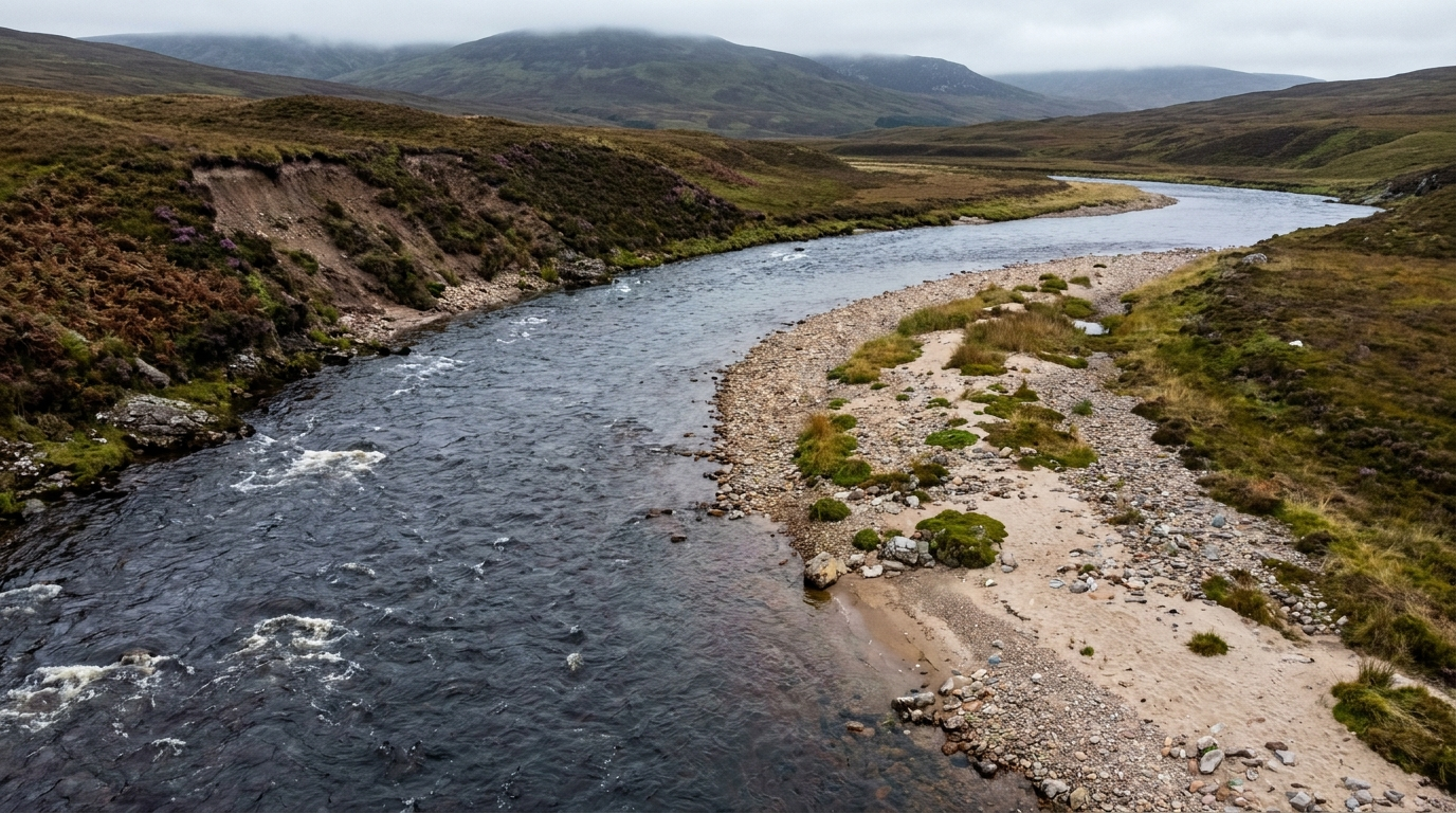
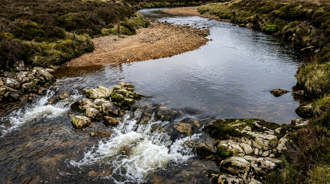
The Strath of Kildonan is a long, narrow glen running roughly north-west from Helmsdale into the Sutherland interior. The Helmsdale River drains the strath and reaches the sea at the village. Two tributaries account for almost all of the recorded gold production from the rush: the Kildonan Burn, joining the Helmsdale a few miles inland near the modern Kildonan railway halt, and the Suisgill Burn, joining the Helmsdale a short distance further upstream from a side glen. Both burns drain country built on Moine metasedimentary rocks cut by intrusions of the Strath Halladale Granite, with the placer gold sourced from deeply weathered zones of the altered granite and concentrated by glacial and post-glacial reworking into the modern stream gravels.

The 1869 prospectors worked the active channels and the gravel bars of both burns directly. The country is open Highland glen — heather hillside, scattered birch and rowan along the watercourses, peat flats on the lower ground and exposed schist or granite bedrock through the channels themselves. The road that runs the length of the strath today follows the line the 1869 prospectors used to move between the diggings, Helmsdale and the satellite camps. Distances are modest by Highland standards — a few miles between the major workings, a dozen or so miles from the head of the strath to the coast — and most of the rush population walked between camp and town as a routine.
The physical scale of the rush itself was, by international comparison, small. There was no county-sized goldfield comparable to the Sacramento Valley or the Victoria fields; there was no week-long trek to reach the workings; there were no permanent towns built around the operation. The Strath of Kildonan rush was concentrated, intense, geographically compact and short. That tight footprint is part of why the cultural memory has survived so well: there is one place to stand, one burn to look at, one village name to remember.
The summer of 1869 in the strath was, by Highland standards, productive weather for placer panning. Contemporary accounts and the surviving weather records for the eastern Highlands describe a season with adequate spring rainfall to clear the winter spates and a settled mid-summer period of low water through July and August. Those are exactly the conditions that expose gravel bars, bedrock cracks and the pressure shadows behind boulders that constitute the headline alluvial traps. The 1869 prospectors had no formal river-reading framework, but they had the practical experience to recognise productive water, and the burns at low summer flow read themselves to anyone with a pan and a few days of practice. The full modern framework for the same intuitive technique is in our river-reading guide.
Baile an Òir — Town of Gold
Baile an Òir, the "Town of Gold" in Scottish Gaelic, was the principal settlement of the rush. It grew up on the lower Kildonan Burn close to the modern Baile an Òir site on the A897 road, a few miles inland from Helmsdale, and at its peak housed several hundred of the 600 prospectors working the field. The buildings were not buildings in the conventional sense — canvas tents, timber-frame and turf shanties, a few more substantial wooden huts, and an improvised store and supply depot run by Helmsdale merchants. There is no record of any permanent stone construction at the site during the rush.
Daily life at Baile an Òir was organised around the burn. Prospectors worked their permitted stretches from dawn through the long northern summer days; meals were prepared in the camp at the start and end of the working day; supplies of flour, oatmeal, tea, sugar and occasional fresh meat came up from Helmsdale on a more or less continuous basis. There is documentary reference to a temporary post office, an improvised chapel for Sabbath services, and the inevitable consumption of alcohol that accompanied every Victorian rush of comparable size. Conditions were not pleasant: late spring and early summer in the strath is reliably wet, the midges are reliably unbearable through July and August, and the canvas-and-turf shelters were what they were.
The economy of the camp ran on credit and the licence-and-royalty framework that the Duke had imposed from the start. Prospectors who recovered enough gold to cover the licence fee continued working; those who did not, drifted away across the season. The supply merchants who ran the store had the most consistent income — they extended credit against the prospectors' anticipated finds and took a percentage of the productive recoveries in repayment. The most lasting material legacy of Baile an Òir is the rubbish: clay-pipe fragments, broken pottery, metal buttons, bottle glass, the remains of cooking hearths and turf walls.
Archaeological excavation of the Baile an Òir site has been carried out in the late twentieth and early twenty-first centuries and the recovered material is held by the Timespan Museum in Helmsdale, where most of the displayed objects of the rush are now curated. The hut bases visible on the ground at the site are subtle but identifiable to a visitor who knows what to look for, and the location is on the modern Suisgill Estate permit framework — meaning a 2026 prospector can pan the same stretch of burn the Baile an Òir occupants worked, under permission.
The social texture of the camp deserves a moment's attention because it explains a lot about why the rush is remembered the way it is. Mid-Victorian Highland society was reliably Sabbatarian — work on a Sunday was socially unthinkable across most of the strath population — and the rush operated on a six-day week with Sunday set aside for chapel, rest and the inevitable mending of kit and clothes. The mix of returning Australian and Californian prospectors with local Highland labour produced a workforce divided along religious and linguistic lines: Gaelic-speaking local men sharing the burn with English-speaking colonials, Free Church adherents alongside Catholics and the unaffiliated, and a steady undercurrent of friction over Sunday observance, the use of public houses and the management of the camp's common ground. The Duke's factor and a small Helmsdale police presence handled the administrative and licensing functions; the social peace of the camp ran on a less formal mixture of mutual interest, shared exhaustion and the practical reality that no individual prospector could afford to make enemies.
Carn na Buth — Hill of Tents
Carn na Buth, the "Hill of Tents", was the satellite camp on the Suisgill Burn a short distance upstream from where it joins the Helmsdale. Smaller than Baile an Òir and occupied by a lighter population through the season, Carn na Buth represented the second front of the rush — the place where prospectors who could not secure a workable stretch on the busier Kildonan Burn went instead, and where the productive but quieter Suisgill workings were concentrated.
The geological reason Suisgill mattered alongside Kildonan is that the Suisgill catchment drains country that is slightly different from the lower Kildonan in ways relevant to the placer gold. The altered granite source that contributes most of the Sutherland gold appears in the Suisgill at a slightly different position in the catchment, the alloy composition of the recovered placer gold is detectably more silver-rich than on the Kildonan, and the proportion of larger flakes and the rare picker is somewhat higher. The 1869 prospectors did not have the geochemical evidence for this — but they did have the empirical evidence of their pans, and the Suisgill diggings persisted through the rush as a productive secondary site for that reason.
The physical character of Carn na Buth followed the same pattern as Baile an Òir but at smaller scale. Canvas and turf shelters, an improvised camp economy, supplies routed up from Helmsdale, a working day defined by the burn. The Suisgill diggings are still on the modern permit scheme and the burn continues to produce flake gold in the same alloy composition the 1869 prospectors recovered.
The Duke's Terms
The licensing framework imposed by the Duke of Sutherland from the opening of the rush was straightforward and entirely under his control as the relevant landowner. The headline conditions were a fee of roughly £1 per prospector per month — a substantial sum for a Highland labourer in 1869, equivalent to a week or more of agricultural wages — and a 10 per cent Crown royalty on declared finds. The licence permitted hand panning and the use of simple hand tools; powered or large-scale equipment was prohibited from the start.
The legal architecture of the Duke's regime is worth a moment of attention. The Royal Mines Act 1424 vested all gold and silver in Scotland in the Crown, and the gold itself remained Crown property regardless of who recovered it from the burn. The Duke's licence was strictly a permission to access the land and disturb the gravel — the gold the prospectors took home was, in the strict legal sense, the Crown's, with the 10 per cent royalty representing the formalised acknowledgement of that fact. The Duke administered the framework on the Crown's behalf as the practical landowner; he did not own the gold itself.
The licensing model was, in retrospect, the most lasting legal contribution of the rush. Modern Scottish recreational gold panning at the Suisgill Estate's Kildonan permit, the Buccleuch Estate's Wanlockhead licence and the Strathfillan Community Development Trust's Tyndrum scheme all derive their conceptual shape from the 1869 model — a landowner permission, a fee, a set of hand-tool conditions, and a tacit accommodation with the Crown's underlying ownership of the gold. The detail has changed; the architecture has not. Full modern context is in our UK gold panning laws guide.
The £1-per-month fee was substantial. A general agricultural labourer in Sutherland in 1869 might earn fifteen to twenty shillings per week — meaning a single month's prospecting licence cost roughly the same as a week of farm work. A licence holder who failed to recover gold worth at least three or four times the fee plus subsistence would be operating at a loss. The structure deliberately concentrated the rush population on people willing to commit to several months of sustained effort, weeded out the casual day-tripper, and gave the Duke a predictable revenue baseline regardless of the actual recovery rates. The 10 per cent royalty on declared finds was, in practice, less effectively enforced than the monthly fee, because the prospectors had every incentive to under-declare and the practical means to do so. The Duke's licensing officers could weigh visible gold at the camp, but the snuffer bottle in a prospector's coat pocket was beyond reach.
One detail worth highlighting because it is often mis-stated by competitor coverage: the Duke of Sutherland was not the Crown. He was a private landowner administering the Crown's underlying gold ownership through the practical mechanism of access control. The £1 fee was the Duke's; the 10 per cent royalty was, in legal form, the Crown's, although the day-to-day administration ran through the Duke's factor and the practical experience of the prospectors was that they paid both amounts to the same office. The same conceptual division between Crown ownership of the gold and landowner control of the access still defines the legal landscape of modern Scottish recreational panning, and is the reason that Crown Estate Scotland, the modern successor body, does not issue recreational licences directly.
What They Actually Found
The headline economic figures for the 1868–69 rush are uncertain. Contemporary estimates of total recorded production range from a few hundred ounces to a few thousand ounces; the true figure depends on what fraction of the actual recoveries were declared to the Duke's licensing officers and what fraction were quietly retained by the prospectors themselves. The 10 per cent royalty was an obvious incentive to under-declare, and most modern historians of the rush settle on a figure closer to the lower end of the range than the higher.
The character of the typical day's pan, however, is well attested. The Kildonan and Suisgill placer gold of the 1869 rush was — and remains — predominantly flake. Sub-millimetre flour gold accounts for the bulk of the count; flat flakes one to two millimetres across account for most of the recoverable mass; the occasional picker of rice-grain size or larger represents the productive day. Nuggets large enough to be picked up between finger and thumb were exceptional even at the rush peak, and the contemporary record of the largest 1868–69 finds is patchy enough that no single piece can be securely identified as the record-holder for the rush itself.
The economics for the individual prospector were brutal. To cover the £1 licence fee and keep yourself fed in the camp, you needed to recover gold worth perhaps three or four pounds per month at the prevailing mid-Victorian price — meaning, in modern terms, you needed perhaps eight to twelve grams of recovered gold per month per person to break even. The productive days delivered that. The unproductive days, weeks and months did not. Most prospectors who worked the Kildonan and Suisgill in 1869 left poorer than they arrived. A small minority left with respectable recovered weights and went home with a story. None of them, on the available record, left wealthy.
The distribution of finds across the working population also followed the standard Pareto pattern that has characterised every recreational gold field since. A small number of skilled or lucky prospectors recovered a disproportionate share of the total gold. The middle of the distribution recovered enough to keep going through the season. The tail recovered nothing of consequence and left within the first weeks or first month. The 1869 rush was, in this respect, identical to the Wanlockhead day-permit experience in 2026 — most people who turn up for a day end up with flour gold and a handful of small flakes, a few find the productive feature and recover well, and the rare exceptional pan goes home to the snuffer bottle of a regular who has spent a season learning the burn.
The cultural significance of the recoveries was always larger than the economic significance. The 1869 rush gave Britain its first and only national conversation about gold panning, established the Kildonan and Suisgill Burns as productive country, and supplied the body of folk tradition and oral memory that every Scottish prospecting trip since has inherited. For technique, see our river-reading guide — the alluvial mechanics the 1869 prospectors worked intuitively are the same mechanics a modern panner works deliberately.
One geochemical detail from the modern era is worth recording here because it links directly to the 1869 experience. Placer gold recovered from the Kildonan and Suisgill Burns in the twenty-first century has been analysed for its silver content and grain morphology by independent researchers, and the results show a subtle but consistent difference between the two catchments — Suisgill gold carries a slightly higher silver fraction and a slightly different distribution of grain sizes than Kildonan gold. The implication is that the two catchments are draining two slightly different source bodies in the underlying Strath Halladale Granite, and the 1869 prospectors who worked both burns and noticed differences in their pans were observing exactly this geochemistry without having the modern vocabulary for it. The flake gold you recover from either burn today is, in alloy composition, the same gold the rush population recovered.
Why It Ended in 1870
The Duke of Sutherland's decision to close the prospecting on his estates from 1 January 1870 was framed at the time and has been remembered since under three official heads. The first was the disruption to the salmon fisheries on the Helmsdale River — a substantial source of estate income, both directly from rod-letting and indirectly from the sporting reputation the river commanded. The 600 prospectors working two of the principal tributaries were inevitably disturbing the gravel beds the salmon used for spawning and the holding pools the fish used during the run.
The second head was the displacement of sheep grazing on the surrounding ground. The Sutherland Clearances had cleared much of the strath for sheep over the previous half-century, and the standing flock represented another substantial source of estate income. Six hundred prospectors and their fires, dogs, supply lines and rubbish disturbed the sheep enough to reduce the carrying capacity of the immediate rush area through 1869.
The third head was the general management cost of accommodating a rush population on what remained, at root, an active sporting estate. The Duke and his factor had to operate a licensing regime, police the camp boundaries, manage the supply traffic up and down the strath, and absorb the reputational complications of having an industrial-scale alluvial operation running across what the rest of the year functioned as deer-stalking and salmon-fishing country.
The unofficial reading is straightforward: the Duke calculated that the salmon and sheep revenue he was losing exceeded the licence-fee income he was gaining, and that the prospect of a quiet sporting estate was worth more to him than the prospect of a noisy goldfield. The closure mechanism was the simplest possible — he owned the surface rights and the salmon fishery, he revoked the access permission, and the rush ended within weeks. The 1 January 1870 date allowed the prospectors who had worked the autumn season to settle their affairs and leave before the formal closure took effect.
Aftermath and Legacy
The rush left three lasting marks on Sutherland and on British recreational gold prospecting more broadly. The first is the Strath of Kildonan itself, which remains the cultural heart of the British hobby a century and a half after the closure. The second is the surviving material culture — the clay pipes, pottery, hut bases and metalwork from Baile an Òir — held by the Timespan Museum in Helmsdale, which functions as the principal interpretive centre for the rush and runs exhibitions and events on the site through the season.
The third and least tangible legacy is the body of folk tradition. The names — Baile an Òir, Carn na Buth, Suisgill, Kildonan — are part of the working vocabulary of Scottish prospecting. The 1869 prospectors' techniques, intuitively applied, are the modern alluvial techniques codified in any river-reading guide. The licensing model the Duke imposed is the conceptual ancestor of the three modern Scottish permit schemes at Kildonan, Wanlockhead and Tyndrum. The lasting cultural fact of the rush is that it gave Britain a single, coherent gold-panning tradition where it might otherwise have had nothing.
A fourth, quieter legacy is worth noting because it bears directly on the modern hobby. The 1868–69 rush established the principle that gold panning was something the British public could legitimately do at all — not just commercially, not just under industrial licence, but as a recreational activity carried out by individuals at a riverside with a hand pan. That principle survived the closure on 1 January 1870 and runs unbroken through the slow Victorian and Edwardian decline, the twentieth-century rediscovery, the establishment of the Wanlockhead and Tyndrum permit schemes in the late twentieth and early twenty-first centuries, and the reopening of Cononish as a commercial mine in 2020. Every modern UK gold prospector inherits the assumption — laid down in the strath in 1869 — that this is something a person can simply do. Our UK Gold Rushes hub places the rush in the wider chronology of British gold history.
The gold itself is still in the burns. The 1869 prospectors removed a few hundred to a few thousand ounces of placer gold across fifteen months; the source rocks have continued to erode and deposit fresh gold into the gravels for the 156 years since; the rivers have been re-sorting both the residual and the freshly delivered gold every winter. The Kildonan and Suisgill Burns produce flake gold today, under the Suisgill Estate's permit framework, in roughly the same alloy compositions and grain size distributions the 1869 prospectors recovered. The wider gold belts of Sutherland are also represented in our UK Gold Rushes hub alongside the Welsh, Cornish and Cumbrian stories.
Visiting Today
The base for any modern visit to the rush country is Helmsdale. The village sits at the mouth of the Helmsdale River on the A9, with the Far North Line railway station — the same line the railhead supplied in the 1870s — providing direct access from Inverness and Wick. Helmsdale has hotels, B&Bs and self-catering accommodation, plus the Timespan Museum and a small but useful collection of supply shops for the standard prospecting kit list.
The Timespan Museum
The Timespan Museum holds the primary collection of material culture from the 1868–69 rush — the excavated artefacts from Baile an Òir, the licensing documents, the contemporary newspaper coverage, and the wider Sutherland material from the surrounding period. It runs the principal exhibition on the rush and is the right first stop for any visitor who wants the historical context before walking the strath itself. Opening hours vary seasonally; check the museum's current opening before travelling.
Baile an Òir on the ground
The Baile an Òir site is identifiable on the ground from the A897 road that runs up the Strath of Kildonan. The hut bases and ground disturbances of the 1869 settlement are subtle but visible to a visitor who has spent twenty minutes in the museum first. The Kildonan Burn at this point is on the Suisgill Estate's modern permit scheme and the access framework is identical to the rest of the Kildonan permit area: buy the day ticket online, follow the SEPA good-practice criteria, hand tools only, no bank digging, no panning between 1 November and 31 May.
The Suisgill Estate permit
The Suisgill Estate's permit scheme covers both the Kildonan Burn upstream of the road bridge at Baile an Òir and the Suisgill Burn through the satellite camp area. The current framework is roughly £15 per adult per day, with discounts for under-16s and for visitors staying in local accommodation, and the season runs from 15 April to 1 October. Confirm current pricing and any seasonal restrictions on the estate's permit page before travelling. The Sutherland article is paired with our Scotland locations guide, which covers the wider permit framework and the modern access at Wanlockhead and Tyndrum as well.
Kit and approach for a retrace
The retrace trip is more rewarding when you carry the lightest viable kit. A 10-inch plastic pan, a quarter-inch classifier, a trowel, a snuffer bottle, a small vial and a stiff brush will outperform any heavier rig if you are reading the burn properly. Neoprene waders are useful for sustained work in the colder summer days; wellies are adequate for shorter sessions in low water. The Suisgill permit allows hand-operated gravel pumps with a barrel of up to 2.5 inches and prohibits sluices; powered equipment is prohibited universally. Full kit detail is in our UK equipment guide, and the technique fundamentals are in our river-reading guide. The combination of a permit, a pan and a half-day's reading should deliver flake gold from the same water the 1869 prospectors recovered theirs from — and for any first-time prospector, that single fact is what makes the Kildonan trip worth making.
The rush ran for fifteen months and produced the body of cultural memory the British hobby still operates on today. The burns are still working. The licence model is still working. The expectation that a modern Saturday at Kildonan is a vial of flakes and the satisfaction of having stood in 1869 country is exactly correct.
Frequently Asked Questions
Where exactly was the Sutherland Gold Rush?
The Strath of Kildonan in eastern Sutherland, north of the coastal village of Helmsdale. The active diggings concentrated on two tributaries of the Helmsdale River — the Kildonan Burn and the Suisgill Burn — both of which join the Helmsdale within a few miles of each other in the upper strath. The Kildonan diggings centred on the Baile an Òir site near the modern Kildonan railway halt; the Suisgill diggings centred on the Carn na Buth camp upstream on the Suisgill Burn.
Who was Robert Gilchrist?
Robert Nelson Gilchrist, born in the Strath of Kildonan and a returning emigrant from the Australian goldfields. Gilchrist spent roughly seventeen years working placer ground in Australia before coming home with a working prospector's eye and the experience to apply it. He obtained the Duke of Sutherland's permission to systematically prospect the Helmsdale tributaries in 1868, recovered enough gold to confirm a workable placer field, and triggered the rush with the end-of-year newspaper announcement of his findings. He is the founding figure of the British recreational gold-panning tradition.
How many people came to the Kildonan gold rush?
Contemporary estimates put the peak population at the Baile an Òir camp and its associated workings at around 600 people in the spring of 1869, with a smaller satellite camp at Carn na Buth on the Suisgill Burn. Prospectors arrived from across Britain and beyond — including a number of returning emigrants from Australia and California, returning soldiers, and locally-based Highland workers attracted by the licence fee model. The Helmsdale hotels were overwhelmed and most prospectors lived in canvas, timber and turf shelters on the burns themselves through the season.
How much gold was actually found in 1868–69?
Modest by international standards and impossible to total precisely. Contemporary and modern estimates of total recorded production range from a few hundred ounces to a few thousand ounces depending on which figure is accepted, with the truth almost certainly closer to the lower end after accounting for unreported finds and the Duke's licensing royalty. A typical day's pan delivered flake gold; a productive day delivered a vial of flakes plus the occasional small picker; nuggets were exceptional even at the peak. The economic significance of the rush was always smaller than the cultural significance.
Why did the Duke of Sutherland close the rush in 1870?
The Duke's stated reasons were the disruption to the salmon fisheries on the Helmsdale River, the displacement of sheep grazing on the surrounding ground, and the general management cost of accommodating 600 prospectors on an active sporting estate. The Duke calculated by the end of 1869 that he was losing more in fishery and grazing revenue than he was earning in licence fees, and announced closure of all prospecting on the estate with effect from 1 January 1870. The closure mechanism was straightforward — the Duke owned the surface rights and the salmon fishery and revoked the prospecting permission that ran with them. The rush ended within weeks.
Can I visit the site of Baile an Òir today?
Yes. The Baile an Òir site is accessible from the road that runs up the Strath of Kildonan from Helmsdale, and the Kildonan Burn at this point is part of the Suisgill Estate's modern permit scheme — meaning you can pan the same water the 1869 prospectors worked, under permission. The archaeological remains of the village have been excavated and the recovered material culture — clay pipes, pottery fragments, hut bases and metalwork — is displayed at the Timespan Museum in Helmsdale, which is the right starting point for any visit to the strath.
Can I still find gold in the Kildonan Burn?
Yes, under the Suisgill Estate permit scheme. The Kildonan Burn continues to produce flake gold reliably and the occasional small picker. The 1869 prospectors worked the same stretches with the same alluvial mechanics; the gold the rush did not remove is still there, plus the gold that has eroded out of the source rocks and into the gravels in the 156 years since. A fair day in late June or July on a permit at Kildonan is comfortably a dozen flakes and a snuffer bottle of black sand. Full modern access detail is in our Scotland locations guide.
What's the largest nugget ever found in Sutherland?
Documentation from the 1868–69 rush is patchy and most recovered pieces were not systematically weighed and recorded, so the answer for the rush itself is uncertain — small pickers up to a few grams were the typical exceptional find and there is no reliable single record-holder. In the modern era, the Reunion Nugget at 121.3 g (2019) is the largest gold nugget recovered in Britain, and although the finder withheld the exact location it is widely attributed to a Highland river system. The previous record holder, the Douglas Nugget at 85.7 g (2016), is on display at the Hunterian Museum at the University of Glasgow.
Where's the best place to start if I want to retrace the rush?
Helmsdale. The village is the historic and modern base for any Kildonan trip — train station on the Far North Line, hotels, the Timespan Museum and the road up the strath. From Helmsdale the A897 runs the length of the Strath of Kildonan, passing Baile an Òir and continuing up to Kildonan station and beyond. A Suisgill Estate permit covers the burns; the Timespan Museum covers the cultural ground. Plan the trip alongside the Scotland locations guide and the interactive map.
Important: The historic Sutherland Gold Rush operated under the Duke of Sutherland's licensing regime in 1868–69. Modern recreational gold panning in the Strath of Kildonan operates under the Suisgill Estate's separate permit scheme — a local landowner arrangement, not a delegated Crown grant. Crown Estate Scotland does not issue recreational gold-panning licences. Always check current permit terms and SEPA good-practice criteria before working any river. Never dig the bank. Do not pan between 1 November and 31 May where Atlantic salmon and trout are present. This article is general guidance, not legal advice. Full detail in our UK gold panning laws guide.
Every Scottish gold location with current permit notes, geology and access information — plan your Sutherland trip before you leave the house.
Open the Interactive Map →Free Beginner's Pack — 16-page PDF: top 10 UK locations with GPS, equipment checklist, legal cheat sheet and app tutorial.
Get the Free Pack →